

Engraved stone attests to westward extension of Qin Dynasty
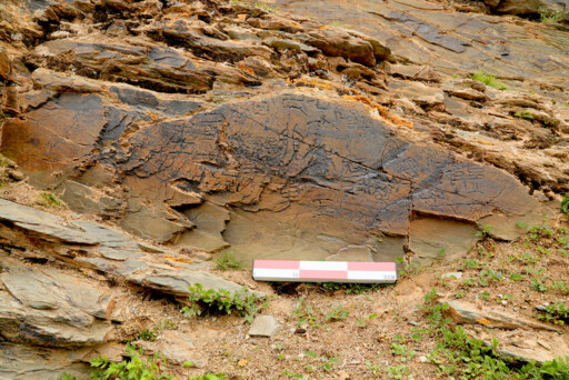
The Garitang Engraved Stone Photo: PROVIDED TO CSST
In June 2025, the Garitang Engraved Stone became the focus of an intense academic debate. Some scholars raised doubts about the regularity of its calligraphy and the logic of its dating system, suggesting that the inscription displayed features of the “new script of the Wei and Jin dynasties (220–420)” or contained chronological inconsistencies, and therefore might be a modern forgery. However, as multidisciplinary research advanced, multiple lines of evidence—including character forms, carving techniques, and the degree of weathering—gradually led to a mainstream academic consensus that the inscription dates to the Qin Dynasty.
Multidimensional evidence for Qin-Dynasty attribution
From the perspective of script and character morphology, the Qin-Dynasty attribution of the inscription is supported by clear evidence. Some scholars have pointed out that the calligraphy on the stone is typical Qin xiaozhuan (small seal script), closely matching the style of other written remains from the dynasty, including the Stone Drum Inscriptions, the Taishan Inscription Stone, the Qin Edicts on Weights and Measures, the Liye Qin bamboo slips, and the Yunmeng Qin bamboo slips. It bears particular resemblance to the scripts found on the Qin edicts and slips, displaying distinctive features of the period.
In response to concerns raised by some scholars—such as “inconsistent character sizes” and “the absence of vertical and horizontal grid lines”—other researchers have offered reasonable explanations grounded in historical context and geographical conditions. Although the Qin Dynasty standardized script styles, this stone inscription was carved in a remote, high-altitude wilderness 4,300 meters above sea level, using locally available materials and executed under pressing circumstances. The inscription had to adapt to an uneven cliff surface and limited stone space.
This is fundamentally different from meticulously crafted, standardized stelae produced in workshops, such as the Taishan Inscription Stone and the Yishan Inscription Stone. Artisans skilled in standard xiaozhuan were already scarce during the Qin Dynasty, and the highest official rank within this envoy team was only Wudafu (Fifth Grandee, the ninth rank in the Qin-Han twenty-rank system of nobility), making it difficult to secure professionally trained calligraphers and carvers of the kind typically reserved for the central court. Under conditions of material scarcity and environmental hardship, irregular character layout and minor variations in brushstrokes are entirely normal.
More importantly, the inscription contains the rank Wudafu written in a combined-character form unique to the Qin and Han (206 BCE–220 CE) periods. These paleographic details serve as key clues for determining the Qin-Dynasty attribution of the stone, and closely match comparable character forms found in the Liye Qin bamboo slips, further corroborating the authenticity of its date.
From the perspective of carving techniques and weathering, archaeological and technical testing offers objective support. Professor Tang Huisheng of Hebei Normal University examined the carved marks under a 60x microscope and found that the edges of the incised characters are smooth, the depth of the cuts varies, and the bottoms are wide and flat, forming U-shaped grooves. This is consistent with the carving marks found on Qin-Dynasty stone inscriptions such as the Stone Drum Inscriptions and the Taishan Inscription Stone, and fundamentally different from the V-shaped grooves commonly seen in modern stone carvings.
A comparison of the micro-weathering of quartz particles with that of the Lushan Rock Art in Tianjun County, Qinghai, showed similar levels of erosion. Combined with the Qin-Dynasty technique of carving stone with a flat-edged chisel, this further supports the conclusion that the inscription has a historical depth of more than two millennia. These traces of natural weathering differ markedly from artificially aged forgeries and serve as important physical evidence for dating the engraved stone.
The broader historical context likewise provides an important layer of indirect support for the authenticity of the stone. After the Qin Dynasty unified the six states, it actively pursued frontier expansion and cultural integration. In addition to major projects such as the construction of the Great Wall and the Qin Zhidao (Direct Road), historical texts such as the Shiji (Records of the Grand Historian) also record the practice of dispatching envoys to explore the frontiers in search of rare treasures and elixirs of immortality.
The destination for herb-gathering recorded on the engraved stone lies within the Xingxiuhai region, west of Gyaring Lake at the source of the Yellow River. This location echoes the account of the Yellow River’s source found in the Shanhai Jing (Classic of Mountains and Seas), and was also a commonly used route for the migration and interaction of the Qiang ethnic group during the Qin and Han periods. This aligns with the historical context of Qin power extending westward and exploring frontier geography.
As a major transportation artery connecting the Central Plains with the northern frontiers, the Qin Zhidao functioned not only for military defense, but also for promoting ethnic interactions and expanding frontier knowledge. The existence of the Garitang Engraved Stone confirms the extension of the Qin transportation network into the northwestern frontier, filling an archaeological gap in the history of the development of the Yellow River source region during the Qin Dynasty.
Kunlun: From specific mountain name to general term
With the Qin Dynasty attribution of the engraved stone increasingly established, the location of “Kunlun,” a term inscribed on the stone, has emerged as another central focus of academic debate. As documentary research and geographical investigation have deepened, one view has gradually gained wider acceptance among researchers: Kunlun was not the name of the specific Kunlun Mountain, but a general term used in different eras to refer to the great mountains of the west. This provides a new perspective for understanding the evolution of ancient geographical knowledge of the frontier regions.
Across different historical periods, the specific referent of Kunlun evolved continuously as geographical knowledge of the frontiers deepened, further confirming its nature as a general term. After Zhang Qian was dispatched on his mission to the Western Regions, he identified the source of the Yellow River with the mountain range in Yutian, present-day Hotan in Xinjiang Uyghur Autonomous Region, based on the geographical features he observed there. Emperor Wu of the Han accordingly consulted ancient maps and texts and named the mountain from which the river issued as Kunlun. At that time, Kunlun referred to the western section of the Kunlun Mountain system east of the Pamir Plateau.
By the Tang Dynasty (618–907), as the scope of field exploration expanded, knowledge of the Yellow River source advanced to the area of present-day Gyaring Lake and Eling Lake, and the referent of Kunlun extended southeastward accordingly. During the Yuan Dynasty (1271–1368), Kublai Khan dispatched envoys to investigate the Yellow River source. The map of the river source they produced marked the eastern section of present-day Anyemaqen Mountain as Kunlun, some 600 to 700 kilometers from Gyaring Lake. It was not until field surveys conducted during the Kangxi reign of the Qing Dynasty (1644–1911) that knowledge of the Yellow River source advanced to the Yueguzongliequ (Yoguzonglie River), approaching today’s scientific conclusion.
This westward and southward movement of the Kunlun designation clearly shows that it was not a fixed, specific mountain name, but a dynamic designation applied by ancient China to the great mountainous regions of the west as frontier exploration progressed. It reflects the deepening geographical understanding of the northwestern frontier among dynasties in the Central Plains across different eras.
The inscription of Kunlun on the Garitang Engraved Stone serves as physical testimony to the understanding of the northwestern frontier during the Qin and Han periods. Given that the stone lies along a migration route used by the Qiang people during the Qin and Han dynasties, the Kunlun mentioned here should be understood as a general term used by Qin envoys to refer to the towering mountain ranges of the Yellow River source region, rather than as the specific name of a single peak.
Although this discovery does not pinpoint the exact geographical location of Kunlun, it does provide concrete evidence that the Qin Dynasty in the Central Plains had already extended their geographical exploration to the core area of the Yellow River source. Its understanding of Kunlun was based on firsthand observation rather than purely mythological imagination, offering valuable material evidence for the study of the formation of frontier geographical knowledge during the Qin and Han periods.
The discovery and scholarly discussion of the Garitang Engraved Stone represent a significant breakthrough in Chinese frontier archaeology and related academic research. The stone not only provides concrete evidence of the Qin Dynasty’s exploration and understanding of the northwestern frontier, filling numerous gaps in the study of Qin-Dynasty frontier history, but also highlights the important value of interdisciplinary research in archaeology.
Wang Minghui is an associate research fellow from the Key Laboratory of Archaeological Sciences and Cultural Heritage at the Chinese Academy of Social Sciences.
Copyright©2023 CSSN All Rights Reserved