
. > WHAT'S NEW > BOOKS
Treasures buried within nomadic maps
Author : WANG ZIJIN Source : Chinese Social Sciences Today 2017-10-18
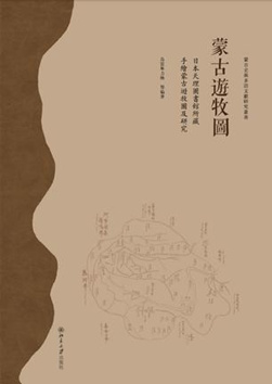
Mongolian Nomadic Maps
Editor: Borjigidai Uyunbilig
Publisher: Peking University Press
Prairie landscapes have played an important role in the exploitation and expansion of transportation networks. Arnold Toynbee, an English historian, said in his work A Study of History, that oceans and prairies were tools for the spread of languages.
Looking back at the history of ancient Chinese diplomacy, it is easy to see that prairie pathways facilitated the spread of language and culture. Ethnic groups in Xiyu, together with prairie nationalities such as Xiongnu and Wusun, showed positive attitudes toward the silk trade that passed through the prairie region. Their demand for trade, expectation of benefits and commercial experience promoted the prosperity of the Silk Road. Joint efforts from multiple ethnic groups in the Han Dynasty contributed to the transportation and cultural pathways between the East and the West.
The strong trade abilities demonstrated by the prairie ethnic groups determined their superior position in the history of transportation and military strength. However, the historical remains of prairie pathways are difficult to preserve. Consider points made in the Records of the Grand Historian: Zhang Qian was General Wei Qing’s guide because he knew the location of oases in the desert. These oases, which determined the traffic paths of the prairie, always changed with the ecological situation, making these pathways difficult to discover for later generations.
However, archaeological findings have shown that key information about prairie transportation can be preserved in cultural relics. A wooden map excavated from a Qin tomb in Fangmatan, Tianshui City, Gansu Province, recorded information on development of forests, land and water routes in the Qin Dynasty. The silk map unearthed from the Han tomb in Mawangdui, Changsha City, Hunan Province, marked the road system of the Han Dynasty.
However, Zhang Qian’s prairie transportation experience was not recorded. Fortunately, some key source materials have been preserved and have become accessible literature after they have been collected and analyzed by scholars. Mongolian Nomadic Maps edited by Borjigidai Uyunbilig, is a good example in this regard. In the book, Uyunbilig and scholars examined 45 hand-painted Mongolian nomadic maps preserved in the Tenri University library in Japan.
These nomadic maps of Mongolia were generally drawn in the Qing Dynasty and the Republic of China period. The map drawers were ordered to investigate the detailed information of certain nomadic regions. For example, the first map is the Map of Central Inner Mongolia and the West-wing of Krakha, describing three passages connecting the historical Chahar region (now in Shanxi and Hebei provinces) and the Republic of Mongolia with clear and concentrated map notes. The second map, Map of Kharachin of the Josutu League, clearly marked names of places such as “Heishakou,” “Guanjiao,” “Danianzi” and “Hengdaozi.” Among them there was a place called “Xindicang,” meaning the cache for materials. Places named “place of the king” were set for the convenience of executive administration.


Ye Shengtao made Chinese fairy tales from a wilderness
Ye Shengtao (1894–1988) created the first collection of fairy tales in the history of Chinese children’s literature...
>> Read More


-
How northern ethnicities integrated into Chinese nation
2023-09-18
-
Mogao caves
2023-09-12
-
Mogao Grottoes as ‘a place of pilgrimage’
2023-09-12
-
Time-honored architectural traditions in China
2023-08-29
-
Disentangling the civilizational evolution of China
2023-08-28
-
AI ethics in science fiction
2023-08-23
 2011-2013 by www.cssn.cn. All Rights Reserved